Central Pyrenees / Ordesa, (Europa , Spain)
Region coordinates
| Latitude | 42.65 DD |
| Longitude | 0.00 DD |
Summits
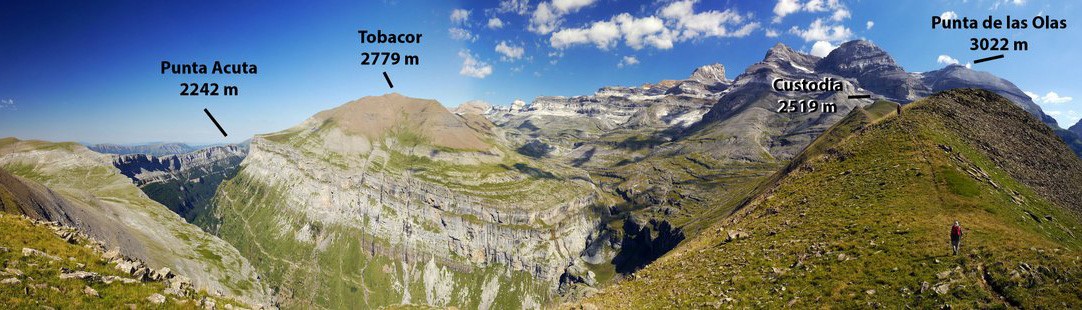
| OLA | 3022 m | nival |
| TOB | 2779 m | upper alpine |
| CUS | 2519 m | lower alpine |
| ACU | 2242 m | treeline ecotone |
Short description & land use (current/history)
The southern slopes of the Monte Perdido Massif (3355 m), thanks to the sunny climate, basic or limestone soils and relief (plateau between 1900 and 2500-2779 m a.s.l., summits 1, 2) and 3 on the base of more than 20 big peaks over passing 3000 m (summit 4) were always attractive for the shepherds of the "Valle de Vió" in order to obtain summer pastures.
Briefly, the four summits of our Target region (ES-CPY) are very well situated in a bioclimatic, edaphic and unique slope of the Monte Perdido Massif. They also belong to Ordesa National Park, Biosphere Reserve, Unesco World Heritage and other protected areas, but were included in the National Park on the occasion of its enlargement in 1982.
Nevertheless, extensive grazing by sheep was always permitted and it is still affecting the two lower summits (1 and 2) as usual all over the Pyrenees. Secondly, summits 3 and 4 are receiving a moderate number of summer tourist visitors.
We would also note that the summer of 2008, if compared with that of 2001, arrived after a spring wetter than usual, so that in the SAS many "new" species appeared in summit 1, perhaps also because sheep and goats arrived some days later than in 2001. But this irregular distribution of precipitation from one year to another is an already known characteristic of the continental climate of the Central Pyrenees, especially in southern slopes.
Finally, in autumn we revisited the 4 summits and took soil samples (out of the SAS section and in the four directions) with our colleague Dr. J. J. Jiménez. Soil analysis and C and N determinations are being currently conducted. This will help us to understand the influence of both abiotic and biotic processes in soil characteristics of the four summits in relation to herbivory presence and geomormphology.
Vegetation boundary lines
The current forestline is here marked by residual small patches of Pinus uncinata besides Summit 1 (Punta Acuta), at 2150 m and neither trees nor shrubs can be seen over this level because of the old fire human action and intensive pressure of domestic herbivores along centuries. Without no doubt, the potential natural forestline would be at 2300-2400 (bioclimatically, in the siliceous Néouvielle Massif reaches 2450, just 13 km to the N). As estimation, the potential natural treeline would be at 2400 (2550 in the Néouvielle). Finally, at about 2800 we clearly pass to the upper alpine and at about 3000-3100 to the nival, because never found dense pastures and the number of plants becomes strongly reduced (near 50 %).